Search the Community
Showing results for tags 'Navigation'.
-

0 comments
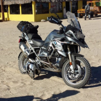
I love my BMW GS Adv. 'Nuff said. Best fun on two wheels since I had a sport bike. If anything my first thought when I bought it, as I rode away from the dealer, was "So THIS is what I'm missing out on."... Life is just different. And now my ZX10r sits in the garage, a proper race queen, having served me reliably for 27,000 miles... My GSA is not only my daily commute but my escape as well. -
2 reviews
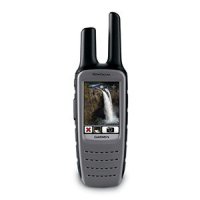
The Navigator V was Co-developed by BMW and Garmin International and is an exclusive BMW Motorrad product that does not have a Garmin consumer equivalent that can be used on motorcycles factory equipped with GPS preparation or with the Motorrad exclusive Advance Cradle. BMW Motorrad has taken trip planning to another level with the Navigator V. Featuring a new larger and brighter 5" TFT Display (800 x 480 pixels and 65,000 colors) than the previous generation Navigator IV, the premium-class, Bluetooth-capable GPS navigation system is a reliable guide both on and off-road, whether traveling by motorcycle or automobile. (NOTE: Does not include a bike-specific mounting bracket which is sold separately.) BMW is pleased to announce the Navigator V! Following on the popularity of the NAV IV, the most widely used Motorrad Navigator ever, BMW Motorrad now offers the new Navigator V. Co-developed by BMW and Garmin International, the Navigator V is an exclusive BMW Motorrad product that will not have a Garmin consumer equivalent capable of being used with motorcycles factory equipped with GPS preparation or the Motorrad exclusive Advance Cradle. The Navigator V has many improvements in features and rider convenience over the previous Navigator IV. Overview -Bigger, brighter 5" display (with same external housing dimensions as NAV IV) with improved readability in direct sunlight. -The integrated storage capacity has been doubled compared to NAV IV (8 GB instead 4 GB). -Improved route planning and navigation logic. -Pre-loaded lifetime (LMU) maps for North America. -Pre-loaded North America BMW Dealer Data base. -Optional Garmin Smartphone Link for traffic information in real time, latest weather en-route and more. -A2DP Stereo Bluetooth technology for hands free telephony, turn-by-turn directions and built in media (MP3) player. -Identical attachment mechanism to NAV IV fits in the existing mount of the 2014-on K1600 series (please choose to add the 2014 instrument cover for earlier machines below, and careful with the satellite radio antenna when removing the original panel (thanks Stephen!)). -3.5 mm jack plug (for headphone connection) and MCX socket (for connecting external antenna). -Compatible with Smartphone Link app via Google Play Store (Android) or iOS App Store (Apple) Contents: -BMW Motorrad Navigator V, including integrated lithiumion battery pack -Free North America map updates for life (up to 4 times per year) -Micro-USB cable -Practical carry bag -Screwdriver -Quick start guide, multilingual -Detailed operating instructions as PDF file on the unit -Garmin ISPI brochure (Important Safety and Product Information) BMW Original Parts PDF Brochure -
I was lucky enough to be invited to do the COBDR (Colorado Backcountry Discovery Route) with the crew from GS Riders of GoAZBMW. They are THE best adventure riding group I have ever seen. They are just very well organized, skilled, motivated and give riders feedback on these trips so that everyone becomes a better rider each time they go out. Their leaders seem to be Jason Houle, who they call "the captain," and Mick Williamson, but many of them are active in ride planning, support, ride leading, etc... like Jason's wife Wendi, Mick's wife Michelle, Ryan Frazier (Team USA GS Trophy '12), Jason Apelquist, Kyle Moore, Janus Lund, Bill Cress, etc... Jason does a lot of these events with RawHyde so the group gets the benefit of his professional experience there. If you ever get the chance to ride with them TAKE IT! I grew up in Arizona and I still go out there a few times/year to see family in the Phoenix/Scottsdale area. I was back in Dec '12 and was invited to go on a ride with them up Cherry Creek road, which is part of day 3 on the AZBDR, so it was nice to have some familiarity with that section. At least there was no snow when we rode the AZBDR in May...
-
1 review
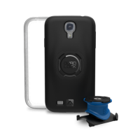
The Quad Lock® Bike Mount Kit for iPhone, Samsung Galaxy and Universal Fit Kits are the lightest and strongest Bike Mounts on the market. Everything you need to secure your smart phone to your bike or motorbike is included in the kit. Never worry about where to put your phone when going on your trip ever again. Have your phone safely secured to your bike, visible and within easy access -
1 review
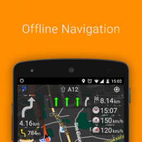
OsmAnd+ (OSM Automated Navigation Directions) is a map and navigation application with access to the free, worldwide, and high-quality OpenStreetMap (OSM) data. All map data can be stored on your device's memory card for offline use. Via your device's GPS, OsmAnd offers routing, with optical and voice guidance, for car, bike, and pedestrian. All the main functionalities work both online and offline (no internet needed).OsmAnd+ is the paid application version. By buying it you support the project, fund the development of new features, and receive the latest updates. Some of the main features: Navigation • Works online (fast) or offline (no roaming charges when you are abroad) • Turn-by-turn voice guidance (recorded and synthesized voices) • Optional lane guidance, street name display, and estimated time of arrival • Supports intermediate points on your itinerary • Automatic re-routing whenever you deviate from the route • Search for places by address, by type (e.g.: restaurant, hotel, gas station, museum), or by geographical coordinates Map Viewing • Display your position and orientation on the map • Optionally align the map according to compass or your direction of motion • Save your most important places as Favorites • Display POIs (point of interests) around you • Can display specialized online tile maps • Can display satellite view (from Bing) • Can display different overlays like touring/navigation GPX tracks and additional maps with customizable transparency • Optionally display place names in English, local, or phonetic spelling Use OpenStreetMap and Wikipedia Data • High quality information from the best collaborative projects of the world • Global maps from OpenStreetMap, available per country or region • Wikipedia POIs, great for sightseeing • Unlimited free download, directly from the app • Always up-to-date maps (updated at least once a month) • Compact offline vector maps • Select between complete map data and just road network (Example: All of Japan is 700 MB, or 200 MB for the road network only) • Also supports online or cached tile maps Safety Features • Optional automated day/night view switching • Optional speed limit display, with reminder if you exceed it • Optional speed-dependent map zooming • Share your location so that your friends can find you Bicycle and Pedestrian Features • The maps include foot, hiking, and bike paths, great for outdoor activities • Special routing and display modes for bike and pedestrian • Optional public transport stops (bus, tram, train) including line names • Optional trip recording to local GPX file or online service • Optional speed and altitude display • Display of contour lines and hill-shading (via additional plugin) Directly Contribute to OpenStreetMap • Report map bugs • Upload GPX tracks to OSM directly from the app • Add POIs and directly upload them to OSM (or later if offline) • Optional trip recording also in background mode (while device is in sleep mode) OsmAnd is open source and actively being developed. Everyone can contribute to the application by reporting bugs, improving translations, or coding new features. The project is in a lively state of continuous improvement by all these forms of developer and user interaction. The project progress also relies on financial contributions to fund the development, coding, and testing of new functionalities. Approximate map coverage and quality: • Western Europe: **** • Eastern Europe: *** • Russia: *** • North America: *** • South America: ** • Asia: ** • Japan & Korea: *** • Middle East: ** • Africa: ** • Antarctica: * Most countries around the globe available as map downloads! From Afghanistan to Zimbabwe,from Australia to the USA. Argentina, Brazil, Canada, France, Germany, Mexico, UK, Spain, ... -
1 comment
This is a great bike. Fun to ride on and off road. -
1 review
Manufacturer Description Take it hiking. Take it hunting. Take it on the water. Montana 650t features a bold 4 in. color touchscreen dual orientation display and TOPO U.S. 100K maps, supports multiple mapping options like BirdsEye™ Satellite Imagery and it has a 5 megapixel camera to boot. Montana has key features for the outdoors such as a 3-axis tilt-compensated compass and barometric altimeter. Buy the auto mount and a City Navigator NT® map, and it'll give you spoken turn-by-turn driving directions. It's big. It's versatile. It's tough. It earned the name Montana - the ultimate in touchscreen toughness. See the Big View Montana 650t features a vast 4 in., sunlight-readable touchscreen display that offers crystal clear enhanced colors and displays high-resolution images. It's easy-to-use interface means you'll spend more time enjoying the outdoors and less time searching for information. Both durable and waterproof, Montana 650t is built to withstand the elements. Bumps, dust, dirt, humidity and water are no match for this rugged navigator. No matter the setting – on the boat, in the RV or on an ATV – Montana is right at home. Take Geotagged Pictures Capture locations and memories with Montana 650t's 5 megapixel digital camera. Each photo is geotagged automatically with the location of where it was taken, allowing you to navigate back to that exact spot in the future. Snap and view pictures in landscape or portrait orientation. To keep track of your photos and show their location on a map, simply connect Montana 650t via USB and use Garmin's free BaseCamp software. For more storage, insert a microSD™ card; you can even view pictures from other devices on microSD with Montana's picture viewer. Go Anywhere With an array of compatible mounts, Montana 650t is designed for use on ATV's, in boats, as a handheld or in your car as a personal navigator. Use the auto mount with City Navigator maps for spoken, Go Everywhere Adding more maps is easy with Garmin's wide array of detailed topographic, marine and road maps. With its microSD™ card slot, Montana 650t lets you load TOPO U.S. 24K maps and hit the trail, plug in BlueChart® g2 preloaded cards for a great day on the water or City Navigator map data for turn-by-turn routing on roads (see maps tab for compatible maps). Montana 650t also supports BirdsEye™ Satellite Imagery (subscription required), that lets you download satellite images to your device and integrate them with your maps. In addition, Montana is compatible with Custom Maps, free software that transforms paper and electronic maps into downloadable maps for your device. Share Wirelessly With Montana 650t you can share your waypoints, tracks, routes and geocaches wirelessly with other compatible Garmin GPS users. So now your friends also can enjoy your favorite hike or cache – simply press "send" to transfer your information to similar units, and let the games begin. Keep Your Fix With its high-sensitivity, WAAS-enabled GPS receiver and HotFix® satellite prediction, Montana 650t locates your position quickly and precisely and maintains its GPS location even in heavy cover and deep canyons. The advantage is clear — whether you're in deep woods or just near tall buildings and trees, you can count on Montana 650t to help you find your way when you need it the most. Navigate with Ease Montana 650t has a built-in 3-axis tilt-compensated electronic compass, which shows your heading even when you're standing still, without holding it level. Its barometric altimeter tracks changes in pressure to pinpoint your precise altitude, and you even can use it to plot barometric pressure over time, which can help you keep an eye on changing weather conditions. Double Your Power Montana 650t features a one-of-a-kind dual battery system. You'll have the option of using the rechargeable lithium-ion pack or traditional AA alkaline batteries – whichever suits your needs better. Find Fun Montana 650t supports geocaching GPX files for downloading geocaches and details straight to your unit. Visit OpenCaching.com to start your geocaching adventure. By going paperless, you're not only helping the environment but also improving efficiency. Montana 650t stores and displays key information, including location, terrain, difficulty, hints and descriptions, which means no more manually entering coordinates and paper print outs! Simply upload the GPX file to your unit and start hunting for caches. Features and Tips Here is a list of Montana 650t features , along with a few user tips. Automatic routing (turn by turn routing on roads): yes (with optional mapping for detailed roads) Electronic compass: yes (tilt-compensated, 3-axis) Touchscreen: yes Barometric altimeter: yes Camera: yes (5 megapixel with autofocus; automatic geo-tagging) Geocaching-friendly: yes (paperless) Custom maps compatible: yes Photo navigation (navigate to geotagged photos): yes Outdoor GPS games: no Hunt/fish calendar: yes Sun and moon information: yes Tide tables: yes Area calculation: yes Custom POIs (ability to add additional points of interest): yes Unit-to-unit transfer (shares data wirelessly with similar units): yes Picture viewer: yes Garmin Connect™ compatible (online community where you analyze, categorize and share data): yes Physical & Performance: Unit dimensions, WxHxD: 2.9" x 5.7" x 1.4" (7.48 x 14.42 x 3.64 cm) Display size, WxH: 2"W x 3.5"H (5.06 x 8.93 cm); 4" diag (10.2 cm) Display resolution, WxH: 272 x 480 pixels Display type: bright, transflective 65k color TFT, dual-orientation touchscreen; sunlight readable Weight: 10.2 oz (289 g) with included lithium-ion battery pack; 11.7 oz (333 g) with 3 AA batteries (not included) Battery: rechargeable lithium-ion (included) or 3 AA batteries (not included); NiMH or Lithium recommended Battery life: up to 16 hours (lithium-ion); up to 22 hours (AA batteries) Waterproof: yes (IPX7) Floats: no High-sensitivity receiver: yes Interface: high-speed USB and NMEA 0183 compatible Maps & Memory: Basemap: yes Ability to add maps: yes Built-in memory: 3.5 GB Accepts data cards: microSD™ card (not included) Waypoints/favorites/locations: 4000 Routes: 200 Track log: 10,000 points, 200 saved tracks -
0 reviews
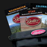
If you are looking for an off road adventure suitable for large Adventure bikes, ride a Backcountry Discovery Route. These maps highlight the official BDR route including fuel stops & camping locations. Includes all of the current BDR maps for Washington, Utah, Arizona and Colorado and a FREE Wolfman carrying case The Backcountry Discovery Routes (BDR) is a community based effort dedicated to establishing and preserving off-highway routes for adventure motorcycle and dual-sport travel. Recent projects include the Washington Backcountry Discovery Route and the Utah Backcountry Discovery Route. -
0 reviews
With a 5 W FRS/GMRS radio, 2.6" glove-friendly color touchscreen GPS with preloaded TOPO 100K maps, barometric altimeter, 3-axis electronic compass, NOAA weather radio and 5-megapixel camera, Rino 655t is a jack-of-all-trades. Rino series from Garmin Pinpoint Your Position With its high-sensitivity GPS receiver and quad helix antenna, Rino 655t quickly finds your position and maintains it – even in heavy cover. Plus, a built-in barometric altimeter and 3-axis compass make it easy to get your bearings without the need to hold it level. See Your Surroundings Rino minisite The device comes preloaded with TOPO 100K maps, which includes coverage of the full U.S. Adding more maps is easy with Garmin's wide array of detailed topographic, marine and road maps. With its microSD™ card slot, Rino 655t lets you load TOPO U.S. 24K maps and hit the trail or plug in BlueChart® g2 preloaded cards for a great day on the water. The device also supports BirdsEye Satellite Imagery (subscription required), that lets you download satellite images to your device and integrate them with your maps. In addition, Rino 655t is compatible with Custom Maps, free software that transforms paper and electronic maps into downloadable maps for your device. Find Your Friends Rino 655t’s unique Position Reporting capability lets you send your exact location to other Rino users so they can see it on their map page. Plus, improved audio performance means it’s easy to communicate with any other conventional FRS/GMRS radio in the area. It can be useful in an emergency, or just a handy way to keep tabs on your hunting party, hiking partner, family or friends. Stay in Touch With plenty of transmit power, Rino 655t also lets you send unit-to-unit text messages to other Rino users in your area – it's ideal for loud or windy conditions, or just when you don't want to disturb the wildlife. It also lets you share your waypoints, tracks, routes and geocaches wirelessly with other compatible Garmin handheld devices. Document Your Journey With Rino 655t’s built-in 5-megapixel autofocus camera, you'll be able to capture the highlights of your outings. Each photo is automatically geotagged with the location of where it was taken, allowing you – or those you share your photos with – to easily navigate back to that spot in the future. View Weather Watches and Warnings For added safety, Rino 655t features a built-in NOAA weather radio that can help you avoid hazardous weather. The radio supports Specific Area Message Encoding, which allows you to see National Weather Service warnings and watches displayed county-by-county on the map screen. Plan Your Next Trip Take charge of your next adventure with BaseCamp™, software that lets you view and organize maps, waypoints, routes, and tracks. This free trip-planning software even allows you to create Garmin Adventures that you can share with friends, family or fellow explorers. BaseCamp displays topographic map data in 2-D or 3-D on your computer screen, including contour lines and elevation profiles. It also can transfer an unlimited amount of satellite images to your device when paired with a BirdsEye Satellite Imagery subscription. Turn Your Computer Into a Base Station The all-new BaseStation lets you turn your laptop (loaded with BaseCamp) into a field command center for tracking multiple Rino units. View real-time GPS information on the larger display of your computer with Rino serving as a router/antenna. And because it’s Garmin GPS-based, safer, more effective search and rescue operations are in your control, even where Internet and cell phone service isn’t. -
1 review
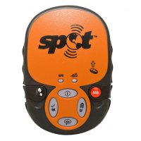
Advanced GPS GPS aquisition light Custom message button Enhanced antenna performance Dedicated tracking button Improved tracking performance Safety covers over S.O.S. and Help buttons Replaceable button covers Illuminated buttons Message sent indicator light Includes armband case Recyclable packaging More Info... SOS: Emergency assistance request sent with your GPS location to GEOS every 5 minutes until batteries die or until cancelled Help/SPOT Assist: Request help from friends and family every 5 minutes for 1 hour. Up to 10 contacts - phone & email Check In: Lets contacts know where you are and that you're okay. Attempts to send three messages to help ensure successful transmission. Up to 10 contacts - phone and email. Contacts will receive only 1 message. Custom Message: Creates custom non-urgent message to send to friends and family Track Progress: Acquires your GPS location every 10 minutes for 24 hours. Sends each location one time. Previous 2 track points sent with current track point helping ensure consistent recording of movements. Emergency Response Center: GEOS is operational 7 days/week, 365 days a year, operating out of Houston, TX (2 addl. backup locations) History Review: Review all Check In, Track Alert SOS, and Help locations via findmespot.com using Google maps for up to 30 days. Shared Page: You can share messages and locations with others via a personal shared page or SPOT adventures account. Live data viewing up to 7 days, data storage up to 30 days. Can have up to 10 shared pages. Button Covers: Prevent accidental activation of SOS or Help features GPS Signal Indicator: Visual LED status of GPS signal acquired Message Sent Indicator: Visual L -
AMSTERDAM - January 15, 2015 - (Motor Sports Newswire) - TomTom (TOM2) today launches the all-new TomTom RIDER, designed to make every motorcycle ride more exciting. For the first time, bikers can choose the level of twists and turns they want to ride to create their own adrenaline-filled adventure. Introducing the all-new TomTom RIDER, designed to make every motorcycle ride more exciting. For the first time, bikers can choose the level of twists and turns they want to ride to create their own adrenaline-filled adventure. The all-new TomTom RIDER helps bikers discover and explore new routes. Simply select an area to ride on the map and TomTom RIDER will suggest the most exciting round-trip. Bikers can build excitement before setting out by creating and sharing touring adventures with friends and uploading direct to their TomTom RIDER. “We believe that every ride is a chance for adventure,” said Corinne Vigreux, co-founder and managing director, TomTom Consumer. “So we have designed TomTom RIDER to give bikers more ways to create and discover exciting routes. From the freedom of cruising the open road, to the thrill of leaning into the tightest curve on the highest peak, with RIDER, bikers can create and ride their own perfect adventure.” The stylish, yet rugged TomTom RIDER has been completely redesigned for life on the road. An innovative rotating mount allows bikers to switch to portrait view to see more of the bends ahead. It has a glove-friendly, interactive screen to make it easy to find and explore new places. Bluetooth® enabled audio instructions delivered to the headset or helmet, give bikers more freedom to just enjoy the ride. TomTom RIDER includes features that are designed specifically for bikers: Winding Roads: Find the most exciting winding roads and avoid the boring straights. Hilly Roads: Stay at sea level or climb the highest peaks. Round-trip Planning: Simply select where you want to ride and TomTom Rider will find the most exciting route. Portrait View: Simple rotate to portrait view to see more of the bends ahead. PC Route Planning: Pre-plan a touring adventure before leaving home. Route Sharing: Share a route with other bikers before setting off or after you return home. Lifetime TomTom Traffic: Ride with real-time traffic information for the lifetime of the device. Audio Instructions via Bluetooth: Keep your eyes on the road with audio instructions delivered through your headset. Track Support: Upload tracks (GPX format) and your TomTom Rider will show you the way. Hands-free Calling: Call hands-free while you ride. Weather-proof Design: As weather ready as you are. Glove-friendly Screen: Use your TomTom Rider even while wearing gloves. Sunlight Visibility: Make use of different colour options for different times of day. Trip Recording: Record your trip and relive the adventure any time. Trip Statistics: See how far, how fast and for how long you have ridden. Fully Interactive Screen: Pinch, zoom and swipe to interact with the map. TomTom RIDER will be available from April 2015. See www.tomtom.com/new-rider-400
-
1 comment
I have to add a full review to add the bike to my garage? Yeah, I'll come back to this. Theme will be: never buy the first year of any model. -
1 review
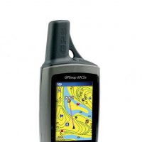
The GPSMAP 60CSx adds several performance-enhancing features to the popular 60-series products, including a removable microSD™ card, high-sensitivity GPS receiver, barometric altimeter and electronic compass. Pinpoint Your Location — and Direction With the GPSMAP 60CSx, you can find your way in almost any conditions: High-sensitivity GPS receiver gives you improved satellite reception even in heavy tree cover or deep canyons Barometric altimeter provides extremely accurate elevation data Electronic compass can determine your heading and direction, even when you're standing still IPX7 waterproof case can withstand an accidental dunk in the water and still perform Large, color TFT display makes viewing the screen easy, day or night Built-in Americas autoroute basemap, including highways, exits and automatic, turn-by-turn directions Add More Detail The 60CSx comes with a blank 64 MB microSD card, so you can store extra maps from optional MapSource® mapping software. Just connect to your computer with the USB cable, and you can load map data or transfer routes and waypoints. You even can purchase microSD cards that are preloaded with MapSource maps, which means you don't have to connect to your computer. The microSD card slot is located inside the waterproof battery compartment, so you never have to worry about water getting inside. GPSMAP 60CSx: Put the great outdoors in the palm of your hand -
Has anyone used this app on their phone as their main GPS? I read some good reviews but I'd like some feedback and tips from people around here... I have a Garmin 60C but having it on the phone seems like it'd be easy to get trails and routes easier.
-
0 reviews
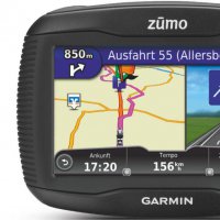
Motorcycle Navigator Loaded with Rider-Friendly Features 4.3” sunlight-readable, glove-friendly touchscreen display Resistant to fuel spills, UV rays and water-rated to IPX7 Service History Log for bike maintenance Lifetime map¹ updates Hands-free phone control and spoken directions via Bluetooth® helmet (sold separately) Curvy Roads routing guides to winding rides Designed By Bikers For Bikers zūmo 390LM has a wide 4.3” touchscreen that is easy to read, even in sunlight. Its glove-friendly intuitive interface makes entering information as easy as shifting gears. With a rugged body that is resistant to fuel sprays and UV rays in addition to being water-rated to IPX7, zūmo 390LM is built for life on the road. The Power of Bluetooth zūmo 390LM features Bluetooth wireless technology. Simply connect your zūmo with your mobile phone and a Bluetooth-enabled headset or helmet (sold separately) to make and receive calls. With it, you’re free to talk on your phone without having to remove your gloves or helmet. You can also call points of interest through the zūmo Bluetooth interface, perfect for a last-minute change of plans or a quick pit stop for food and fuel. zūmo 390LM can transmit voice prompts to your compatible headset or helmet (sold separately). Hearing street names and navigation commands lets you keep your focus on the road. Curvy Roads Ride your favorite twisty. Let zūmo 390LM navigate to winding rides. Service History Log Tire mileage, tire changes, tire pressure, chain cleanings, oil changes, new spark plugs: let zūmo 390LM keep track of it all. Use the included Service History Log to record date, mileage and performed maintenance. Lifetime Map Updates zūmo 390LM includes free map updates for the useful life¹ of your device, so routes reflect the most up-to-date points of interest and maps available. Navigation Tools Lane assist with junction view displays junctions and interchanges on your route. A brightly colored arrow indicates the proper lane position needed for your next turn or exit. zūmo 390LM has TracBack® so you can navigate right back to where you started, along the same route. Exit Services lists gas stations and restaurants for upcoming exits. The Skip feature allows you to skip your next waypoint with ease. Nice Extras zūmo 390LM has a built-in trip computer with compass display. It comes standard with a digital fuel gauge so you can estimate how many miles you can ride before a fuel stop. There’s a speed limit indicator so you know when to throttle down. In addition to a motorcycle mount, zūmo 390LM includes an automotive mount and power cable for travel in a car. Plan and Share Rides Plan your next trip with BaseCamp™. You can create routes along specific roads and search for, and save, points of interest, including local attractions, restaurants and fuel stops. Then, upload your pre-planned trip to zūmo and follow along for a stress-free ride. Garmin Adventures, powered by BaseCamp, is a free, interactive way to record and share your rides. With BaseCamp, you can combine track logs, waypoints, geotagged photos, YouTube® videos and more into an adventure that you share online. Garmin Adventures also allows you to rate your trips, read reviews and download routes shared by other riders. Easily Monitor Tire Pressure zūmo 390LM is compatible with our integrated Tire Pressure Monitor Sensor (sold separately). Add a TPMS sensor for each tire and easily monitor the pressure using your zūmo display. The system works with up to 4 tires in any configuration (not intended for automotive use). One TPMS sensor is required for each tire (sold separately; metal valve stems only). VIRB® Compatible zūmo 390LM is compatible with our VIRB HD action camera (sold separately). Control VIRB using your zūmo display and you can easily record and relive every ride.